In the Horn of Africa, delivering routine immunisation services can often be a challenge for health planners and vaccinators, particularly for communities living in areas facing insecurity, conflict, or crisis.
In humanitarian settings, some communities struggle to access this foundational health service due to insecurity, conflict, and crisis, exacerbated by factors such as remoteness or population mobility. These barriers make it particularly difficult for health planners to identify and reach children, resulting in a large number of zero-dose or partially-vaccinated children.


The REACH Consortium — funded by Gavi, the Vaccine Alliance under ZIP, its Humanitarian Partnerships Programme; led by the International Rescue Committee (IRC); with Flowminder as the geospatial data lead) — was designed to close the immunisation gap in selected conflict-affected communities in Ethiopia, Somalia, South Sudan, and Sudan.
The programme focuses on identifying and locating children in missed communities to ensure they receive all essential childhood vaccines including the DPT vaccine (a combination vaccine that protects against diphtheria, pertussis, and tetanus), and ensure that no child is left behind, wherever they live in those countries. The programme aims to identify and locate zero-dose children, and distribute essential childhood vaccines.
Enhancing immunisation planning with geospatial data
A core component of our work within the REACH consortium is the creation and distribution of microplanning support documents, such as maps and data tables, for local health planners. These resources help optimise outreach efforts by identifying the most strategic locations for mobile and outreach services, ensuring maximum population coverage with limited resources.
The maps highlight key data, including recommended locations for new outreach and mobile vaccination sites, generated by our optimisation algorithm. By integrating data on existing fixed sites and on population distribution, we pinpoint areas with the highest concentration of uncovered people with a 5km radius. Sites are then ranked by priority, enabling decision makers to efficiently allocate resources and improve immunisation coverage.

Piloting data-driven outreach in Southwest Somalia
In Somalia’s Southwest region, the Rural Education and Agricultural Development Organisation (READO) is responsible for implementing REACH immunisation services. Despite achieving targets, they have faced challenges in fully identifying and prioritising areas where potential beneficiaries reside, as not all locations are well-documented or easily accessible.
As part of an innovative pilot approach to validate data and gather user feedback, READO used our microplanning support documents to identify and reach new communities from Bulojimac fixed vaccination site in Baidoa.

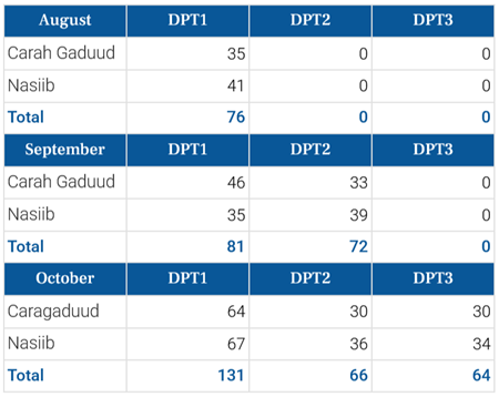
READO initially selected six sites to prioritise from the suggested locations, based on security and logistics, before narrowing it down to two feasible locations — Carah Gaduud and Nasiib.
Given resource constraints, it was crucial to select sites with the highest potential impact, and Flowminder’s data played a pivotal role in this decision-making process. By using targeted microplans and geospatial data, the team was able to identify and serve communities previously left out of national health services.

The two selected sites are in partially accessible areas, and we knew that large displacements previously occurred there. One of the reasons why we chose to target those areas was when we realised, looking at Flowminder’s maps, that there were still many people there who were still underserved.
— Adan Kerow, GAVI REACH Project Manager at READO

From July to October 2024, READO led a successful immunisation campaign in Carah Gaduud and Nasiib, complemented by strong community engagement, to reach previously unreached children.
Strengthening community engagement for increased uptake
Beyond geospatial support from Flowminder, READO has been working closely with ThinkPlace, a global design and strategy firm within the Gavi REACH consortium, which focuses on enhancing vaccine demand through human-centred design interventions. These interventions include immunisation card games, decision games, and a zero-dose immunisation programme handbook. Prior to deploying vaccination teams, READO conducted sensitisation activities, engaging village elders, leaders, and traditional birth attendants to highlight the benefits of vaccinations and share success stories. Local community health volunteers further reinforced these efforts, fostering greater vaccine acceptance as more individuals saw the positive impact of the programme.


Each site hosted two vaccination sessions per month, with monitoring and evaluation data indicating a steady increase in vaccine uptake. Notably, most children who received their first dose of DPT in August 2024 returned each month to complete the three-dose regimen.
Additionally, in the first month of the campaign, all the DPT vaccines delivered were first doses. While infants typically receive this vaccine as a first dose as part of routine immunisation, most children vaccinated in this campaign were aged 11-59 months, an indication of reaching previously unvaccinated, zero-dose children.
Over three months, DPT1 and total vaccination delivery tripled across the two mobile sites, demonstrating both the effectiveness and accuracy of the site selection and success of community engagement efforts.
Without Flowminder's pilot data - these two missed communities would not have been served.
— Mohamed Dhiif, HMIS Officer at READO.
Our data played a crucial role in guiding READO’s outreach efforts.
READO commended the clarity and user-friendliness of the maps, which provided detailed insights into population distribution, road networks, and viable outreach locations.
The data has been very accurate.
— Kassim Abdi, MEAL Manager, at READO.
Looking ahead
The insights gained from this pilot are invaluable. Not only do they underscore the effectiveness of our optimisation solution and microplanning support documents, but they also provide critical feedback for refining tools and methodologies going forward.
Discussions are underway to integrate additional data layers, such as terrain and security analysis, as well as migration patterns and displacement data, to enhance these geospatial models.

Results from this pilot study are promising. We're looking forward to continuing to deliver our geospatial and optimisation solutions within the REACH programme, as well as other countries moving forward.
— Alistair Steward, Spatial Data Analyst & Data Use Adviser at Flowminder.
Learn more
For more information about our optimisation solution, click on the link below:
If you’re interested in this solution for your own programme, would like to discuss your needs, or want to support this work, please contact us at optimisation@flowminder.org
For more optimisation success stories, check out this video on how Nigeria increased its vaccination coverage with spatial optimisation during COVID-19.
Photo credits: READO (except where marked with the Flowminder watermark).
Some photos have been edited to either blur the faces of identifiable children or digitally remove them for privacy reasons.